
Why Developers Order Topographic Surveys Before Designing Large Residential Communities
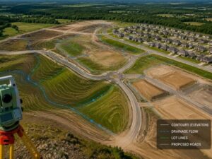
A topographic survey gives developers the ground truth they need before laying out a large residential community. Roads, lots, drainage and utilities all depend on how the land rises and falls, and a flat map can’t show that. When a design ignores real elevation, water pools in the wrong places and roads meet slopes they were never built for. So developers order this survey early to shape the whole plan around the land’s actual form.
A big community magnifies every terrain issue across hundreds of homes. A drainage flaw that seems small on one lot can flood a street when it repeats across a phase. Detailed elevation data lets the design handle those problems before they multiply, which protects both the budget and the future residents.
Large Communities Need Accurate Ground Data Before Design
Designing a community means placing roads, homes and utilities in a way that fits the land. Each of those pieces depends on knowing the exact heights and slopes across the site. Without that data, the layout rests on guesswork that shows up later as trouble, and trouble at that scale is expensive.
A topographic survey records the elevation and features across every part of the property. Engineers then work from a true model of the ground instead of a flat outline. That accuracy carries through every stage of the design, from the first road to the last lot line.
The size of a community makes small data errors expensive. A slope misread by a foot might not matter on one lot, but the same error repeated across a whole phase can throw off drainage for dozens of homes. Accurate ground data at the start stops that kind of error from spreading through the entire plan.
Slope and Drainage Can Shape the Entire Site Plan
The way land slopes decides how water moves across it, and water drives many design choices. A community has to guide runoff safely away from homes and roads. If the plan misreads the slopes, drainage fails and problems spread across the whole site.
Terrain details that a topographic survey helps clarify include:
- Steep areas that limit where roads can run
- Low spots where water tends to collect
- Natural drainage paths that shape lot layout
- Slope changes that affect grading and cost
Topographic Surveys Help Engineers Plan Roads and Lot Layouts
Roads need gentle enough grades for safe driving and proper drainage, and topographic data makes that possible. Engineers use the elevations to route streets along workable slopes. They also fit lots to the land so each home sits on stable, drainable ground rather than a problem spot.
Good elevation data keeps the road network and the lot pattern working together. When the terrain is clear, the layout flows with the land instead of against it. That harmony saves grading work and produces a smoother community, which shows in both the cost and the finished streets.
Lot grading depends on the same data. Each home needs a pad that drains away from the foundation and ties into the street at a workable height. With clear elevations, engineers set those pads correctly the first time, which spares buyers the drainage headaches that plague poorly graded lots.
Early Terrain Review Can Reduce Costly Design Revisions
Reviewing the terrain before committing to a plan spares a developer expensive changes down the road. A layout drawn without elevation data often unravels once the real slopes appear. Early review lets the team design with those slopes already in mind, so the first plan comes closer to the last.
Developers who study the terrain up front avoid the cost of redrawing roads and lots midstream. The first plan then reflects the land as it truly is, which keeps approvals and construction on schedule. That foresight keeps the project on budget and spares the team a painful round of rework.
Why Topographic Data Supports Smarter Phasing Decisions
Large communities usually build in phases, and terrain often decides which phase makes sense first. Areas with gentler slopes and simpler drainage can move ahead faster. Steeper or wetter sections may need more prep before they’re ready for homes.
With topographic data in hand, a developer can sequence the work in a logical order. Easier ground comes first, which brings early progress and revenue to fund the rest. The harder parts follow once the plan and the budget can absorb them, so the whole build stays steady.
Phasing around the terrain also helps a developer manage cash and crews. Building the simpler ground first brings homes to market sooner, and that early income supports the harder work ahead. Terrain data turns phasing from a guess into a plan the budget can actually follow.
Frequently Asked Questions
Why do developers need a topographic survey?
It shows the elevation, slope and surface features that road, lot and drainage design all rely on. With that data, a developer can plan a community that fits the land rather than fighting it.
Can a topographic survey help with drainage planning?
Yes. By mapping how the ground rises and falls, it lets engineers see where water will flow and collect. That understanding guides a drainage plan that keeps homes and roads dry through heavy weather.
When should developers order a topographic survey?
Early, before any site design, grading plan or engineering work begins. Ordering it up front gives the whole team accurate ground data from the start.
For a free land surveying quote, call us at (502) 557-1757 or send us a message by going here.
Posted in Topographic Survey