
How Land Surveys Help Resolve Property Questions Before Industrial Site Expansion
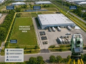
A land survey answers the first big question in any industrial expansion, which is what the existing site really contains. Owners who want to add buildings, storage yards, drives or utility areas need clear facts before they commit to a layout. Guessing at boundaries or forgotten easements can send a plan sideways once construction crews arrive. So the survey settles those questions early and keeps the growth on solid ground.
Industrial sites tend to be large, busy and full of moving parts. A small mistake in the layout can ripple across drainage, access and safety in ways that are hard to reverse. Knowing the land in detail lets engineers design around real conditions rather than assumptions, and that saves both money and time.
Industrial Expansion Starts With Knowing the Existing Site
Before adding anything, an owner needs a clear map of what’s already on the property. That map shows current buildings, paved areas, utilities and the space left for growth. Without it, a plan can collide with features nobody accounted for, and the collision usually costs a redesign.
A survey turns the site into a measured picture that engineers can trust. It marks where structures sit, how the ground lies and where the open room remains. Starting from that picture keeps the expansion grounded in fact, so the plan reflects the site instead of a hopeful sketch.
A clear site map also helps an owner spot rooms that might have gone unused. Older industrial lots often hold odd corners or setback strips that a fresh survey brings to light. Finding that hidden space can change the whole expansion, since a few extra feet in the right place can fit another bay or a wider drive.
Property Lines Can Affect Where Expansion Is Possible
The property lines set the outer edge of everything an owner can build. A new warehouse or yard has to fit inside those lines with the right spacing. If the lines aren’t confirmed, a design can push past them without warning, which invites a dispute with a neighbor.
A survey pins down the boundaries so the layout stays within legal limits. Engineers can then position new structures with room for setbacks and access. Confirmed lines keep the plan from overreaching the land the owner actually holds, and they protect the project from a late boundary fight.
Easements and Utility Areas Can Limit Expansion Plans
Recorded easements and existing utility corridors carve out parts of a site that stay off-limits for building. A buried pipeline, a power line or a drainage easement can sit right where an owner hoped to expand. Ignoring those features leads to conflicts that halt work fast, and stopping a crew mid-job is never cheap.
Site constraints that can limit industrial expansion include:
- Utility corridors carrying power, water or gas lines
- Drainage easements that must stay open for runoff
- Access easements shared with neighboring parcels
- Buffer areas required around sensitive site features
Survey Information Helps Engineers Plan Safer Site Improvements
Engineers rely on survey data to design grading, drainage, access and layout that hold up over time. Accurate ground information helps them route water away from buildings and shape stable surfaces. Good data leads to improvements that work in real weather, not just on paper, which matters on a site that runs heavy equipment daily.
When the survey is precise, the engineering follows more smoothly. Crews build from plans that match the actual site, which cuts down on surprises during construction. That accuracy protects both the schedule and the people working the job, since fewer surprises mean fewer hazards.
Drainage deserves special attention on a working industrial site. Heavy vehicles, stored materials and wide paved yards all change how water moves, and poor drainage can flood a work area fast. Survey data lets engineers plan grades that carry runoff away from the parts of the site that stay busy all day.
Why Early Survey Review Can Reduce Redesign Costs
Catching a property issue before design starts is far cheaper than fixing it midway through. A boundary conflict or a hidden easement found late can force an engineer to redraw a plan already in motion. Early survey review removes that risk before it grows into a real expense.
Owners who review survey findings up front give their design team a clean starting point. The plan then reflects real limits from the first draft, so there’s less to unwind later. That head start keeps costly redesigns off the table and the expansion moving forward.
Early review also gives lenders and local reviewers time to weigh in before the design hardens. Their questions are easier to answer while the plan is still flexible. Handling that input up front keeps approvals on schedule and the expansion on budget.
Frequently Asked Questions
Why does an industrial site need a land survey before expansion?
A survey confirms the boundaries, existing improvements, access and the limits that shape where new work can go. That information lets an owner plan growth that fits the site instead of fighting it.
Can easements affect industrial expansion?
Yes. Easements can hold parts of a property open for utilities, drainage or shared access, which keeps those areas off-limits for building. Knowing where they fall helps an owner steer the expansion around them before design begins.
Who uses the survey during expansion planning?
Owners, engineers, contractors, lenders and local review teams all draw on it. Each group needs the same accurate base to design, approve and build the project without conflict.
For a free land surveying quote, call us at (502) 557-1757 or send us a message by going here.
Posted in land surveying, land surveyor